
Commons Locations Ontology
OMG GraphArch rendering of the Commons 1.3 formal specification
- Copyright © 2024-2025, Adaptive Analytics, Inc.
- Copyright © 2022-2025, agnos.ai U.K. Ltd.
- Copyright © 2024-2025, Airbus Group
- Copyright © 2024-2025, Boeing
- Copyright © 2024-2025, Dassault Systèmes
- Copyright © 2024-2025, DEKonsult
- Copyright © 2022-2026, EDM Council, Inc. d/b/a EDM Association
- Copyright © 2024-2025, 88Solutions
- Copyright © 2022-2025, Federated Knowledge, LLC
- Copyright © 2024-2025, GfSE e.V.
- Copyright © 2024-2025, Mayo Clinic
- Copyright © 2022-2025, OntoAge
- Copyright © 2024-2025, Ontogenesis Solutions, LLC
- Copyright © 2023-2025, Pistoia Alliance
- Copyright © 2024-2025, ProSTEP iViP Association
- Copyright © 2024-2025, Raytheon Technologies
- Copyright © 2022, QuoteWell, Inc.
- Copyright © 2024-2025, Sparx Systems Pty Ltd
- Copyright © 2022-2025, Stardog Union
- Copyright © 2022-2025, Thematix Partners LLC
- Copyright © 2022-2025, University of North Florida
- Copyright © 2022-2025, Working Ontologist
- Copyright © 2022-2026, Object Management Group, Inc.
USE OF SPECIFICATION – TERMS, CONDITIONS & NOTICES
The material in this document details an Object Management Group specification in accordance with the terms, conditions and notices set forth below. This document does not represent a commitment to implement any portion of this specification in any company's products. The information contained in this document is subject to change without notice.
LICENSES
The companies listed above have granted to the Object Management Group, Inc. (OMG) a nonexclusive, royalty-free, paid up, worldwide license to copy and distribute this document and to modify this document and distribute copies of the modified version. Each of the copyright holders listed above has agreed that no person shall be deemed to have infringed the copyright in the included material of any such copyright holder by reason of having used the specification set forth herein or having conformed any computer software to the specification.
Subject to all of the terms and conditions below, the owners of the copyright in this specification hereby grant you a fully-paid up, non-exclusive, nontransferable, perpetual, worldwide license (without the right to sublicense), to use this specification to create and distribute software and special purpose specifications that are based upon this specification, and to use, copy, and distribute this specification as provided under the Copyright Act; provided that: (1) both the copyright notice identified above and this permission notice appear on any copies of this specification; (2) the use of the specifications is for informational purposes and will not be copied or posted on any network computer or broadcast in any media and will not be otherwise resold or transferred for commercial purposes; and (3) no modifications are made to this specification. This limited permission automatically terminates without notice if you breach any of these terms or conditions. Upon termination, you will destroy immediately any copies of the specifications in your possession or control.
PATENTS
The attention of adopters is directed to the possibility that compliance with or adoption of OMG specifications may require use of an invention covered by patent rights. OMG shall not be responsible for identifying patents for which a license may be required by any OMG specification, or for conducting legal inquiries into the legal validity or scope of those patents that are brought to its attention. OMG specifications are prospective and advisory only. Prospective users are responsible for protecting themselves against liability for infringement of patents.
GENERAL USE RESTRICTIONS
Any unauthorized use of this specification may violate copyright laws, trademark laws, and communications regulations and statutes. This document contains information which is protected by copyright. All Rights Reserved. No part of this work covered by copyright herein may be reproduced or used in any form or by any means--graphic, electronic, or mechanical, including photocopying, recording, taping, or information storage and retrieval systems--without permission of the copyright owner.
DISCLAIMER OF WARRANTY
WHILE THIS PUBLICATION IS BELIEVED TO BE ACCURATE, IT IS PROVIDED "AS IS" AND MAY CONTAIN ERRORS OR MISPRINTS. THE OBJECT MANAGEMENT GROUP AND THE COMPANIES LISTED ABOVE MAKE NO WARRANTY OF ANY KIND, EXPRESS OR IMPLIED, WITH REGARD TO THIS PUBLICATION, INCLUDING BUT NOT LIMITED TO ANY WARRANTY OF TITLE OR OWNERSHIP, IMPLIED WARRANTY OF MERCHANTABILITY OR WARRANTY OF FITNESS FOR A PARTICULAR PURPOSE OR USE. IN NO EVENT SHALL THE OBJECT MANAGEMENT GROUP OR ANY OF THE COMPANIES LISTED ABOVE BE LIABLE FOR ERRORS CONTAINED HEREIN OR FOR DIRECT, INDIRECT, INCIDENTAL, SPECIAL, CONSEQUENTIAL, RELIANCE OR COVER DAMAGES, INCLUDING LOSS OF PROFITS, REVENUE, DATA OR USE, INCURRED BY ANY USER OR ANY THIRD PARTY IN CONNECTION WITH THE FURNISHING, PERFORMANCE, OR USE OF THIS MATERIAL, EVEN IF ADVISED OF THE POSSIBILITY OF SUCH DAMAGES.
The entire risk as to the quality and performance of software developed using this specification is borne by you. This disclaimer of warranty constitutes an essential part of the license granted to you to use this specification.
RESTRICTED RIGHTS LEGEND
Use, duplication or disclosure by the U.S. Government is subject to the restrictions set forth in subparagraph (c) (1) (ii) of The Rights in Technical Data and Computer Software Clause at DFARS 252.227-7013 or in subparagraph (c)(1) and (2) of the Commercial Computer Software - Restricted Rights clauses at 48 C.F.R. 52.227-19 or as specified in 48 C.F.R. 227-7202-2 of the DoD F.A.R. Supplement and its successors, or as specified in 48 C.F.R. 12.212 of the Federal Acquisition Regulations and its successors, as applicable. The specification copyright owners are as indicated above and may be contacted through the Object Management Group, 9C Medway Road, PMB 274, Milford, MA 01757, U.S.A.
TRADEMARKS
CORBA®, CORBA logos®, FIBO®, Financial Industry Business Ontology®, FINANCIAL INSTRUMENT GLOBAL IDENTIFIER®, IIOP®, IMM®, Model Driven Architecture®, MDA®, Object Management Group®, OMG®, OMG Logo®, SoaML®, SOAML®, SysML®, UAF®, Unified Modeling Language®, UML®, UML Cube Logo®, VSIPL®, and XMI® are registered trademarks of the Object Management Group, Inc.
For a complete list of trademarks, see: https://www.omg.org/legal/tm_list.htm. All other products or company names mentioned are used for identification purposes only, and may be trademarks of their respective owners.
COMPLIANCE
The copyright holders listed above acknowledge that the Object Management Group (acting itself or through its designees) is and shall at all times be the sole entity that may authorize developers, suppliers and sellers of computer software to use certification marks, trademarks or other special designations to indicate compliance with these materials.
Software developed under the terms of this license may claim compliance or conformance with this specification if and only if the software compliance is of a nature fully matching the applicable compliance points as stated in the specification. Software developed only partially matching the applicable compliance points may claim only that the software was based on this specification but may not claim compliance or conformance with this specification. In the event that testing suites are implemented or approved by Object Management Group, Inc., software developed using this specification may claim compliance or conformance with the specification only if the software satisfactorily completes the testing suites.
OMG’s Issue Reporting Procedure
All OMG specifications are subject to continuous review and improvement. As part of this process, we encourage readers to report any ambiguities, inconsistencies, or inaccuracies they may find by completing the Issue Reporting Form listed on the main web page https://www.omg.org, under Specifications, Report a Bug/Issue (https://issues.omg.org/issues/create-new-issue).
1. Commons Locations Ontology§
This ontology provides a very high level definition of geographic region and geopolitical entity related concepts, including, but not limited to, countries, sub-country regions such as states and provinces, and municipalities. The representation was derived from a combination of ISO 3166, the UN M49 Region codes, Geonames, the SWIFT registry, the UN FAO and CIA World Factbook, and other sources. It aims to provide a systematic description of the vocabulary used for country and geopolitical entity representation, useful for mapping among the various names and codes for countries and their subdivisions used world-wide, including but not limited to FIPA and International Olympics codes for countries, (based strictly on requirements for business applications, not broader geographic or political uses).The terms defined herein terms are reused by the OMG's LCC controlled vocabulary representing ISO 3166 country and country subdivision codes, and may be mapped to other standards and de facto standards such as those mentioned.
Metadata for the Commons Locations Ontology is given in Commons Locations Ontology Metadata.
| Metadata Term | Value |
|---|---|
|
Ontology IRI |
|
|
|
Commons Locations Ontology |
|
|
This ontology provides a very high level definition of geographic region and geopolitical entity related concepts, including, but not limited to, countries, sub-country regions such as states and provinces, and municipalities. The representation was derived from a combination of ISO 3166, the UN M49 Region codes, Geonames, the SWIFT registry, the UN FAO and CIA World Factbook, and other sources. It aims to provide a systematic description of the vocabulary used for country and geopolitical entity representation, useful for mapping among the various names and codes for countries and their subdivisions used world-wide, including but not limited to FIPA and International Olympics codes for countries, (based strictly on requirements for business applications, not broader geographic or political uses).The terms defined herein terms are reused by the OMG's LCC controlled vocabulary representing ISO 3166 country and country subdivision codes, and may be mapped to other standards and de facto standards such as those mentioned. |
|
|
Elisa Kendall, Thematix Partners LLC |
|
|
Evan Wallace, U.S. National Institute of Standards and Technology (NIST) |
|
|
Pete Rivett, Federated Knowledge, LLC |
|
|
Roy Bell, Thematix Partners LLC |
|
|
Copyright (c) 2015-2017 Unisys |
|
|
Copyright (c) 2015-2025 Adaptive Analytics, Inc. |
|
|
Copyright (c) 2015-2025 EDM Council, Inc. |
|
|
Copyright (c) 2015-2025 Object Management Group, Inc. |
|
|
Copyright (c) 2015-2025 Thematix Partners LLC |
|
|
Copyright (c) 2019-2025 agnos.ai UK Ltd. |
|
|
Copyright (c) 2021-2025 Federated Knowledge, LLC |
|
|
Copyright (c) 2015-2025 Adaptive Analytics, Inc. Permission is hereby granted, free of charge, to any person obtaining a copy of this software and associated documentation files (the 'Software'), to deal in the Software without restriction, including without limitation the rights to use, copy, modify, merge, publish, distribute, sublicense, and/or sell copies of the Software, and to permit persons to whom the Software is furnished to do so, subject to the following conditions: The above copyright notice and this permission notice shall be included in all copies or substantial portions of the Software. THE SOFTWARE IS PROVIDED 'AS IS', WITHOUT WARRANTY OF ANY KIND, EXPRESS OR IMPLIED, INCLUDING BUT NOT LIMITED TO THE WARRANTIES OF MERCHANTABILITY, FITNESS FOR A PARTICULAR PURPOSE AND NONINFRINGEMENT. IN NO EVENT SHALL THE AUTHORS OR COPYRIGHT HOLDERS BE LIABLE FOR ANY CLAIM, DAMAGES OR OTHER LIABILITY, WHETHER IN AN ACTION OF CONTRACT, TORT OR OTHERWISE, ARISING FROM, OUT OF OR IN CONNECTION WITH THE SOFTWARE OR THE USE OR OTHER DEALINGS IN THE SOFTWARE. See https://opensource.org/licenses/MIT. |
|
|
|
|
|
|
|
|
This ontology is largely derived from the Object Management Group's Languages, Countries and Codes (LCC) standard (to provide a more general ontology on which LCC can depend) and the Financial Industry Business Ontology (FIBO) Locations and Virtual Locations ontologies. |
|
|
The https://www.omg.org/spec/Commons/20240801/Locations.rdf version of this ontology was modified to add support for WGS 84 (COMMONS-1.3-28) and add a hasPrimarySubdivision property to enable better querying (COMMONS13-35). |
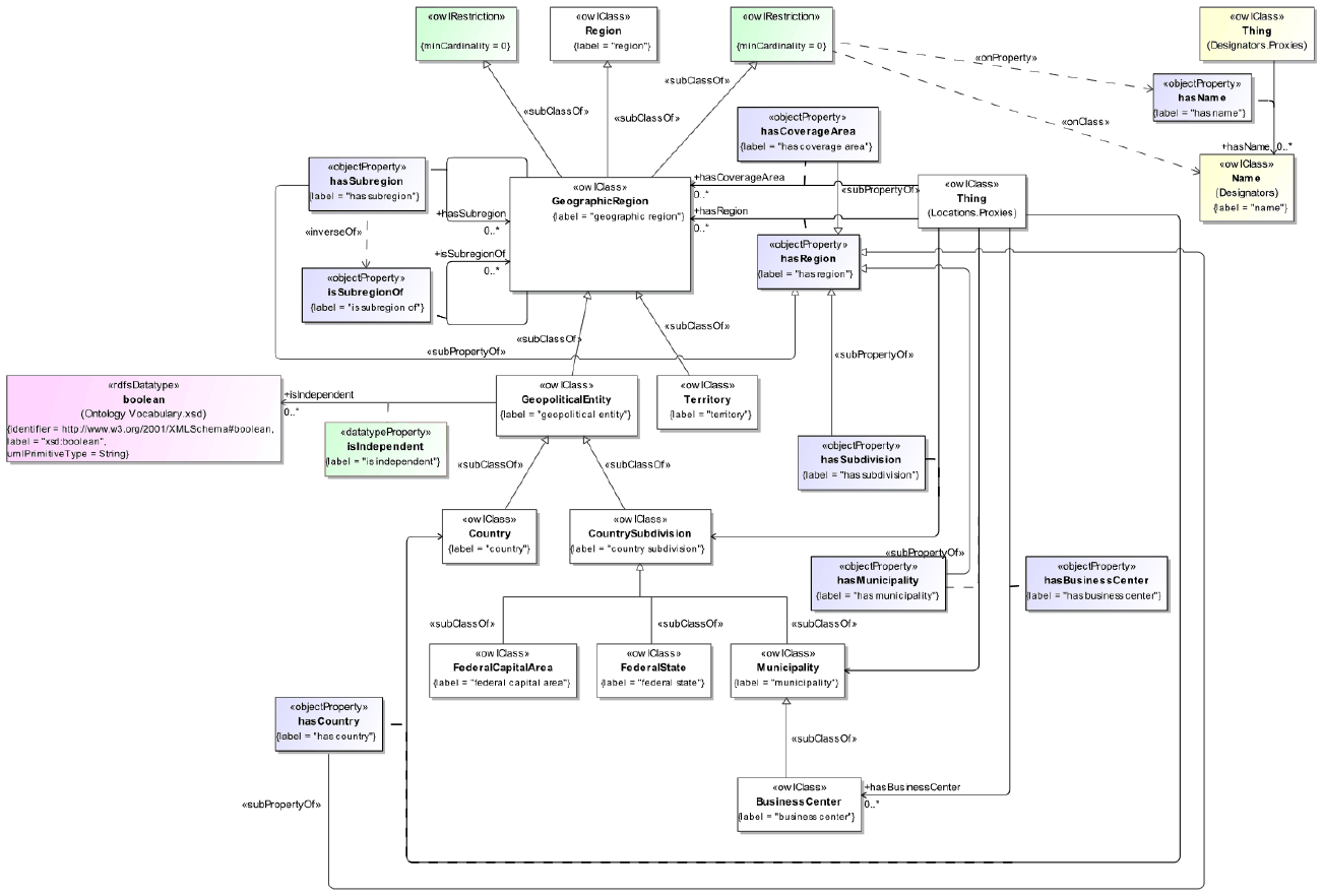
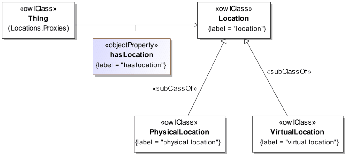
The detailed annotations and axioms that comprise the Commons Locations Ontology are provided in Commons Locations Ontology Details, below.
Classes
| Name | Annotations | Class Expressions |
|---|---|---|
|
BusinessCenter (business center) |
Definition: municipality where business is conducted, especially one that is considered a financial center Adapted from: FpML Business Center and related codes, see http://www.fpml.org/coding-scheme/business-center-7-14.xml |
Parent Class: Municipality |
|
Country (country) |
Definition: geopolitical entity representing a distinct territorial body or political entity or dependent territory Explanatory note: It may be an independent sovereign state or part of a larger state, as a non-sovereign or formerly sovereign political division, a physical territory with a government, or a geographic region associated with sets of previously independent or differently associated peoples with distinct political characteristics. See also: https://datahelpdesk.worldbank.org/knowledgebase/articles/906519 See also: https://www.un.org/development/desa/dpad/wp-content/uploads/sites/45/2017wesp_annex_en.pdf |
Parent Class: GeopoliticalEntity Property Restriction: = 1 isIndependent.xsd:boolean |
|
CountrySubdivision (country subdivision) |
Definition: geopolitical entity that is a legal division of a country, dependency, or other area of special geopolitical interest related to a country or other geopolitical entity Explanatory note: In the US, the US Census Bureau and other federal agencies may group some number of other subdivisions for statistical analysis and reporting purposes, ranging from multiple states to minor civil divisions. See also: https://www.census.gov/programs-surveys/popest/guidance-geographies/terms-and-definitions.html |
Parent Class: GeopoliticalEntity Property Restriction: ∃ cmns-cls:isClassifiedBy.GeographicRegionKind |
|
County (county) |
Definition: political and administrative division of a country, state or province, providing certain local governmental services |
Parent Class: CountrySubdivision |
|
FederalCapitalArea (federal capital area) |
Definition: country subdivision that is or includes the municipality or capital city that acts as the seat of the federal government Example: Examples include the District of Columbia in the US, and the Canberra area in Australia. Explanatory note: The capital administrative region of some federations includes those for which the capital is situated other than within one of the states or provinces which make up the country as a whole. |
Parent Class: CountrySubdivision |
|
FederalState (federal state) |
Definition: self-governing geopolitical unit which forms part of a wider geopolitical unit that is recognized as a country Synonym: canton Synonym: province Synonym: state Explanatory note: This type of entity, variously referred to as a state, province or canton, has a level of self government including its own legal system and court jurisdiction, but cedes a level of autonomy to the federation of which it forms a part. |
Parent Class: CountrySubdivision |
|
GeodeticCoordinateSystem (geodetic coordinate system) |
Definition: three-dimensional reference system that is a global frame of reference for precisely representing the position of locations on Earth or other planetary bodies by means of geodetic coordinates Example: The three most widely used systems for indicating point locations in the United States are (1) latitude and longitude [and optionally elevation], (2) Universal Transverse Mercator (UTM) system, and (3) State Plane Coordinate Systems (SPCS). Note: The unit of measure is usually decimal degrees. A point has two coordinate values, latitude and longitude. Latitude and longitude measure angles. Explanatory note: Geodetic coordinates are crucial to any technology or technique based on spatial location, including geodesy, navigation, surveying, geographic information systems, remote sensing, and cartography. Source: http://edndoc.esri.com/arcsde/9.1/general_topics/what_coord_sys.htm |
Parent Class: cmns-col:Arrangement |
|
GeographicRegion (geographic region) |
Definition: area of land that has common features Explanatory note: A region may be defined by natural or artificial features, and may be described as part of a country or the world having definable characteristics but not always fixed boundaries. Usage note: Many cases in which a geographic region, or subclass thereof, is mapped to certain applications or a relational store, or where codes are used to identify the region, require a class to represent the name of the region. In such situations, attributes of the name, such as the dates when a particular name was in use, or was valid under certain circumstances, may be important. For other applications, such as for addressing, a text value may be required. Thus, both options are provided here, with a preference for use of the full class option, depending on the use case. Source: https://www.nationalgeographic.org/encyclopedia/region/ |
Parent Class: Region Property Restriction: ≥ 0 cmns-dsg:hasTextualName Property Restriction: ≥ 0 cmns-dsg:hasName.cmns-dsg:Name |
|
GeographicRegionIdentificationScheme (geographic region identification scheme) |
Definition: identification scheme dedicated to the unique identification of geographic regions |
Parent Class: cmns-id:IdentificationScheme |
|
GeographicRegionIdentifier (geographic region identifier) |
Definition: string of letters that indicates a code or other identifier for geographical region, assigned for the purpose of uniquely identifying it within some context |
Parent Class: cmns-cds:CodeElement, cmns-id:Identifier Property Restriction: ∃ cmns-id:identifies.GeographicRegion Property Restriction: ∃ cmns-txt:hasTextValue.xsd:string Property Restriction: = 1 cmns-col:isMemberOf.GeographicRegionIdentificationScheme |
|
GeographicRegionKind (geographic region kind) |
Definition: classifier for a geographic region, including but not limited to a subdivision of a geopolitical entity, (noting that there may be more than one kind for a given country or other entity) |
Parent Class: cmns-cls:Classifier Property Restriction: ∀ cmns-cls:classifies.GeographicRegion |
|
GeopoliticalEntity (geopolitical entity) |
Definition: geographic area that represents a geophysical location associated with some form of political structure Example: A geopolitical entity may be any country, federal province, city or other administrative unit that represents a geophysical location |
Parent Class: GeographicRegion |
|
Location (location) |
Definition: place or position in time and/or space, including a virtual place |
|
|
Municipality (municipality) |
Definition: urban administrative division having corporate status and usually powers of self-government or jurisdiction Example: A municipality can be any political jurisdiction from a sovereign state, such as the Principality of Monaco, or a small village, such as West Hampton Dunes, New York. Explanatory note: A municipality is a general-purpose administrative subdivision, as opposed to a special-purpose district. Scope note: The territory over which a municipality has jurisdiction may encompass: - only one populated place such as a city, town, or village - several of such places (e.g., early jurisdictions in the state of New Jersey (1798-1899) as townships governing several villages, Municipalities of Mexico) - only parts of such places, sometimes boroughs of a city such as the 34 municipalities of Santiago, Chile. |
Parent Class: CountrySubdivision |
|
PhysicalLocation (physical location) |
Definition: location in physical space |
Parent Class: Location |
|
Region (region) |
Definition: area that is a continuous part of a surface, space, or body |
|
|
Territory (territory) |
Definition: geographic area, typically considered an area of special geopolitical interest, subject to the sovereignty, control, or jurisdiction of a state or other entity Note: Certain territories are included in the ISO 3166-2 code set without an alpha 2 or alpha 3 code. In these cases, the numeric code for the subregion may have more than 3 characters in their corresponding numeric region codes. |
Parent Class: GeographicRegion |
|
VirtualLocation (virtual location) |
Definition: place that does not exist in any single physical location Example: a network-based location without geographic boundaries |
Parent Class: Location Class Axiom: ¬ PhysicalLocation |
Properties
| Name | Annotations | Property Axioms |
|---|---|---|
|
geo:alt |
Note: WGS 84 provides the 'alt' property as an RDF property, so we declare it here to enable use in OWL. However, we have not made it equivalent to hasAltitude due to the potential semantic clash for people using 'alt' with string values or numeric values with different units. |
|
|
geo:lat |
Note: WGS 84 provides the 'lat' property as an RDF property, so we declare it here to enable use in OWL. However, we have not made it equivalent to hasLatitude due to the potential semantic clash for people using 'lat' with string values or numeric values with different units. |
|
|
geo:long |
Note: WGS 84 provides the 'long' property as an RDF property, so we declare it here to enable use in OWL. However, we have not made it equivalent to hasLongitude due to the potential semantic clash for people using 'long' with string values or numeric values with different units. |
|
|
hasAltitude (has altitude) |
Definition: the height or vertical elevation of a point above a reference surface Note: Altitude measurements are usually based on a given reference datum, such as mean sea level. Source: https://support.esri.com/en-us/gis-dictionary/altitude See also: geo:alt |
Parent Property: cmns-qtu:hasNumericValue Range: xsd:decimal |
|
hasBusinessCenter (has business center) |
Definition: identifies a location where business is conducted, and hence the business calendar used to adjust dates |
Parent Property: hasMunicipality Range: BusinessCenter |
|
hasCityName (has city name) |
Definition: indicates the name of a typically large, permanent, and densely settled place Explanatory note: Typical working definitions for small-city populations start at around 100,000 people. Common population definitions for an urban area (city or town) range between 1,500 and 50,000 people, with most U.S states using a minimum between 1,500 and 5,000 inhabitants. Some jurisdictions set no such minima. Usage note: This property should be used in cases where a formal individual for the business center or municipality is not available. Note that Geonames could be used as a source in cases where an individual is desired. Use the property cmns-loc;hasMunicipality in cases where an individual is available. Also note that with respect to an address, this property may stand in for any village, town, or city of any size. Adapted from: https://en.wikipedia.org/wiki/City Adapted from: https://www.gleif.org/en/about-lei/common-data-file-format/current-versions/level-1-data-lei-cdf-3-1-format |
Parent Property: cmns-dsg:hasTextualName |
|
hasCountry (has country) |
Definition: indicates a country, such as one that is recognized by the United Nations Adapted from: https://www.gleif.org/en/about-lei/common-data-file-format/current-versions/level-1-data-lei-cdf-3-1-format |
Parent Property: hasRegion Range: Country |
|
hasCounty (has county) |
Definition: indicates a country subdivision providing certain local governmental services |
Parent Property: hasSubdivision Range: County |
|
hasCoverageArea (has coverage area) |
Definition: indicates a geographic region in which some service is provided, or to which some policy applies, or in which something is available |
Parent Property: hasRegion Range: GeographicRegion |
|
hasLatitude (has latitude) |
Definition: the angle formed by the intersection of a line perpendicular to the Earth's (or other celestial body's) surface at a point and the plane of the Equator Note: Points north of the Equator have positive latitude values, while points south have negative values. Latitude values range from minus 90 to plus 90 degrees. Lines of latitude are also called parallels because a particular value of latitude forms a circle parallel to the Equator. Source: https://support.esri.com/en-us/gis-dictionary/latitude See also: geo:lat |
Parent Property: cmns-qtu:hasNumericValue Range: xsd:decimal[≤ "90"^^xsd:decimal, ≥ "-90"^^xsd:decimal] |
|
hasLocation (has location) |
Definition: relates something to a location, which might be physical or virtual |
Range: Location |
|
hasLongitude (has longitude) |
Definition: the angle between a plane that passes through the point and the North and South poles, and a reference plane Note: The reference plane is known as the prime meridian. The most common prime meridian passes through Greenwich, United Kingdom. Other examples of prime meridians in use pass through Paris and Bogota. Longitude values range from minus 180 to plus 180 degrees. Source: https://support.esri.com/en-us/gis-dictionary/longitude See also: geo:long |
Parent Property: cmns-qtu:hasNumericValue Range: xsd:decimal[≤ "180"^^xsd:decimal, ≥ "-180"^^xsd:decimal] |
|
hasMaximumLatitude (has maximum latitude) |
Definition: indicates the highest value / maximum for latitude with respect to a range |
Parent Property: hasLatitude Range: xsd:decimal |
|
hasMaximumLongitude (has maximum longitude) |
Definition: indicates the highest value / maximum for longitude with respect to a range |
Parent Property: hasLongitude Range: xsd:decimal |
|
hasMinimumLatitude (has minimum latitude) |
Definition: indicates the lowest value / latitude with respect to a range |
Parent Property: hasLatitude Range: xsd:decimal |
|
hasMinimumLongitude (has minimum longitude) |
Definition: indicates the lowest value / longitude with respect to a range |
Parent Property: hasLongitude Range: xsd:decimal |
|
hasMunicipality (has municipality) |
Definition: indicates a business center, city, or municipality Usage note: Note that certain greater metropolitan areas span multiple counties or states (e.g., the greater Washington, D.C. area, which includes parts of Maryland and Virginia, and divided/disputed cities such as Jerusalem), thus hasMunicipality is a subproperty of hasRegion rather than hasSubdivision. |
Parent Property: hasRegion Range: Municipality |
|
hasPrimarySubdivision (has primary subdivision) |
Definition: identifies the most immediate and main subdivision of a country, such as a state or province Usage note: This property is intended for use when using RDF entailment or other inferencing to query for only the primary subdivisions of a geopolitical entity and eliminate references to smaller subdivisions, such as counties, from being returned in results, if present in the data set. |
Parent Property: cmns-col:hasDirectPart, hasSubdivision Range: CountrySubdivision |
|
hasRegion (has region) |
Definition: indicates a demarcated area on the surface of the Earth |
Range: GeographicRegion |
|
hasSubdivision (has subdivision) |
Definition: identifies a country subdivision (state, province, region, etc.) Adapted from: https://www.gleif.org/en/about-lei/common-data-file-format/current-versions/level-1-data-lei-cdf-3-1-format |
Parent Property: hasRegion Range: CountrySubdivision |
|
hasSubregion (has subregion) |
Definition: relates a geographic region to another geographic region that is a designated subregion of it |
Parent Property: cmns-col:hasPart, hasRegion Domain: GeographicRegion Range: GeographicRegion |
|
isIndependent (is independent) |
Definition: indicates whether a geopolitical entity stands alone or is considered part of another geopolitical entity (e.g., a country) |
Domain: GeopoliticalEntity Range: xsd:boolean |
|
isSubregionOf (is subregion of) |
Definition: relates a geographic region to another geographic region that it is a part of |
Parent Property: cmns-col:isPartOf Domain: GeographicRegion Range: GeographicRegion Inverse: hasSubregion |